What does it mean to introduce coordinate system on a regular tiling?
I suppose there could be many valid answers to this question, but I’ll just go with one that is especially convenient for my puproses.
Let’s take hexagonal tiling $\{6, 3\}$ for example. Coordinate system assigns some unique
representation to every tile in a grid:
data Hexagon = ???
    deriving Eq
Given hexagon, we might want to get list of all its direct neighbors, in counter-clockwise order (does not matter where this list starts, we will think of it as a cycle anyway):
adjacent :: Hexagon -> [Hexagon]And finally, we need some way to begin exploration of the grid.
Constant origin holds representation of some tile in the grid (does not
matter which one):
origin :: HexagonSo how this abstract data type should be implemented? Here is one possible approach:
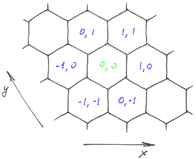
data Hexagon = Hexagon Int Int
    deriving Eq

origin :: Hexagon
origin = Hexagon 0 0

adjacent :: Hexagon -> [Hexagon]
adjacent (Hexagon x y) = [
    Hexagon (x + 1) y,
    Hexagon (x + 1) (y + 1),
    Hexagon x (y + 1),
    Hexagon (x - 1) y,
    Hexagon (x - 1) (y - 1),
    Hexagon x (y - 1)]
Note that although this set of operations completely captures
the structure of the grid,
it might not be the most efficient choice for certain applications.
For example, finding shortest path between two tiles
can be done purely in terms of equality checks and adjacent
(without looking directly at x and y),
but that would be terribly slow.